GEOGRAFÍA
|
|
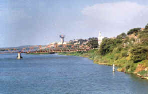
Sullana está ubicada a orillas del caudaloso río Chira Sullana is located beside the mighty river Chira Sullana wird neben dem gewaltigen Fluß Chira gefunden
|
|
UBICACIÓN GEOGRÁFICA DE LA CIUDAD DE SULLANA La provincia de Sullana tiene una extensión de 5,423.61 Km² y un perímetro provincial de 445 Kms. según el Instituto Geográfico Nacional. La
provincia de Sullana, limítrofe con el Ecuador, abarca la mayor parte
de la hoya del Chira. Sus bastas tierras de cultivo de la margen
derecha, se extienden hasta los linderos con el país del norte. La mayor parte del territorio es más bien plano. En el Alto Chira, atraviesa de N.O. a S.O el sistema montañoso de Amotape, que es un ramal desprendido de la Cordillera de los Andes, ubicándose en la parte norte los cerros de La Brea, casi en el límite con el departamento de Tumbes, encontrándose su mayor altura en el cerro el Carrizal con 1,613 m.s.n.m. en el linderos con Tumbes. Otros cerros son el del Viento(con 1,298, metros de altura, Conchudo con 981, Cabullo con 918, Tinajones con 829. Dentro de su territorio, que es en parte quebrado, están ubicadas la pampa de Jíbito y parte de la pampa de La Pera. UBICACIÓN
GEOGRAFICA La provincia fronteriza de Sullana está situada en la parte media y al norte del departamento de Piura entre las coordenadas geográficas 80º 13’ 19” y 80º 56’ 13” de longitud oeste y 4º 4’ 15” y 5º 14’ 86” de latitud sur. La provincia de Sullana
comprende ocho distritos que son:
Bellavista, Ignacio Escudero, Lancones, Marcavelica, Miguel Checa,
Querecotillo, Salitral y Sullana Es preciso aclarar que no
debemos confundir los términos de provincia de Sullana y distrito de
Sullana. En el primer caso abarca todo el territorio provincial que
incluye los ocho distritos. En lo referente al distrito de Sullana es en
sí sólo la ciudad de Sullana y alrededores, sin Bellavista, tal como
veremos más adelante. LIMITES: La provincia de Sullana
limita: - Por el Norte con el departamento de Tumbes y República de Ecuador. - Por el Sur con la
provincia de Piura. - Por el Este con la
provincia de Ayabaca y Piura. - Por el Oeste con las
provincias de Paita y Talara. CAPITAL La capital de la provincia de Sullana, es el distrito de Sullana que se halla a 60 m.s.n.m. y ubicada a la margen izquierda del río Chira. Es
preciso indicar que la ciudad de Sullana se encuentra a 1,040 kilometros
al norte de la capital del Perú, Lima; y a sólo 60 kilómetros del
puerto marítimo de Paita
|
GEOGRAPHICAL LOCATION OF THE CITY DE SULLANA The county of Sullana has an extension of 5,423.61 Km² and a provincial perimeter of 445 Kms. according to the National Geographical Institute. The county of Sullana, bordering with the Ecuador, it embraces most of the valley of the Chira. Their coarse lands of cultivation of the right riverbank, extend until the boundaries with the country of the north. Most of the territory is rather plane. In the High Chira, it crosses of N.O. to S.O the mountainous system of Amotape that is a removed brunch of the Mountain range of you Walk them, being located in the north part the hills of The Pitch, almost in the limit with the department of you Knock down, meeting their biggest height in the hill the Carrizal with 1,613 meters on the level of the sea, in the boundaries with you Knock down. Other hills are that of the Wind (with 1,298, meters high, Conchudo with 981, Cabullo with 918, Tinajones with 829. Inside their territory that is broken partly, they are located the pampas of Jíbito and it leaves of the pampas of La Pera. GEOGRAPHICAL LOCATION LIMIT: The county of Sullana limits: - For the North with the department of you Knock down and Republic of Ecuador. - For the South with the county of Piura. - For the This with the county of Ayabaca and Piura. - For the West with the counties of Paita and Talara. CAPITAL The capital of the county of Sullana, is the district of Sullana that is to 60 meters on the level of the sea. and located to the left riverbank of the river Chira. It is necessary to indicate that the city of Sullana is to 1,040 kilometers to the north of the capital of the Peru, Lima; and to only 60 kilometers of the marine port of Paita |
GEOGRAPHISCHE LAGE DER STADT DE SULLANA Die Grafschaft von Sullana hat eine Vergrößerung von 5,423.61 Km² und einer provinziellen Umgrenzung von 445 Kms. dem Nationalen Geographischen Institut zufolge. Die Grafschaft von Sullana, beim Grenzen mit dem Ekuador, die es das meiste des Tales vom Chira umarmt. Ihre groben Länder von Kultivierung des richtigen Flußufers, strecken Sie sich bis die Grenzen mit dem Land des Nordens aus. Das meiste des Territoriums sind lieber Flugzeug. Im Hohen Chira überquert es von N.O. zu S.O geht das bergige System von Amotape, der ein entferntes Brunch vom Gebirgszug von Ihnen ist, sie gefunden im Norden Teil die Hügel Des Peches, klopfen Sie fast in der Begrenzung mit der Abteilung von Ihnen hinunter und trifft ihre größte Höhe im Hügel der Carrizal mit 1,613 Metern auf dem Niveau des Meeres, in den Grenzen mit Ihnen klopfen Sie hinunter. Andere Hügel sind das vom Wind (mit 1,298, Meter hoch, Conchudo mit 981, Cabullo mit 918, Tinajones mit 829. In ihrem Territorium, das teilweise gebrochen wird, werden sie die Pampas von Jíbito gefunden, und es geht von den Pampas von La Pera. GEOGRAPHISCHE LAGE Es ist notwendig aufzuklären, daß wir die Bedingungen von Grafschaft von Sullana und Gebiet von Sullana nicht verwirren sollten. Im ersten Fall umarmt es das ganze provinzielle Territorium, das die acht Gebiete einschließt. Hinsichtlich des Gebietes von Sullana ist es in ja nur die Stadt von Sullana und Umgebungen, ohne Bellavista. BEGRENZUNG: Die Grafschaft von Sullana Begrenzungen: -Für den Norden mit der Abteilung von Ihnen klopfen Sie hinunter und Republik von Ekuador. -Für den Süden mit der Grafschaft von Piura. -Für das Dieses mit der Grafschaft von Ayabaca und Piura. -Für den Westen mit den Grafschaften von Paita und Talara. KAPITAL Das Kapital von der Grafschaft von Sullana, ist das Gebiet von Sullana, der zu 60 Metern auf dem Niveau des Meeres ist. und fand zum linken Flußufer des Flusses Chira. Es ist notwendig zu zeigen, daß die Stadt von Sullana zu 1,040 Kilometern zu ist, das nördlich vom Kapital vom Peru, Lima; und zu nur 60 Kilometern vom See Hafen von Paita |
|
visite la web: |
||