GEOGRAFÍA
RÍO CHIRA
|
|
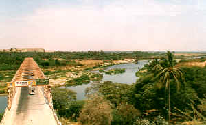
El valle del río Chira The valley of the river Chira Das tal des flusses Chira |
|
EL
RÍO CHIRA. La
cuenca del río Chira está ubicada entre las coordenadas 4º 7’
latitud sur, y entre 77º23’ y 81º06’ de longitud oeste. Limita por
el norte con la cuenca del río Tumbes y el Ecuador, por el este con la
cuenca del río Quiroz y por el sur con la cuenca del río Piura y por
el oeste con el litoral piurano. Su cuenca colectiva abarca una extensión
total de 17,550 km² de los cuales 10,630 km² (61%) corresponden a
territorio peruano y el resto a Ecuador. La
provincia, hidrográficamente, es recorrida de nor-este a sur oeste por
el río Chira de curso contante y caudaloso y, entre los de la vertiente
del Pacífico en la costa peruana, ocupa el segundo lugar por el volumen
de agua. El Diccionario Geográfico de Paz Soldán, indica que este río
nace en Ecuador, en las lagunas de Mamayocos y Huarigas, en los
deshielos del nudo de Loja, en el su curso recibe numerosos
tributarios, como los ríos Catamayo o Santa Rosa y Macará o Calvas,
que también nacen en Ecuador. El Catamayo corre en dirección S.E. y el
Macará hacia el oeste, sirviendo de frontera con Ecuador. El río Macará,
con el nombre de río Calvas, llega a territorio peruano y en el sitio
denominado Anchalay en el punto conocido como La Toma, distrito de Suyo,
provincia de Ayabaca, se une al río Catamayo y desde allí cambia el
nombre por el del Chira, sirviendo siempre de frontera, se dirige hacia
el éste hasta la Solana, donde toma rumbo sud-oeste ingresando de lleno
en la provincia de Sullana. Son
afluentes del Chira, el río Quiroz que nace en los cerros de Japón,
Buitreros y las lagunas Negras y Huaringas, todos sobre 3,000 m.s.n.m.,
su confluencia con el
Chira se produce en el punto llamado Los Encuentros a 180 metros de
altura. Otro afluente es el río Chipillico o Suipirá que nace en las
alturas de Poclús en distrito de Frías, provincia de Ayabaca y que
confluye con el Chira en Chilaco. Por la margen derecha tiene como
tributario el Alamor que sirve de límite con Ecuador. Muchos de estos
lugares son mencionados en el Protocolo de Río de Janeiro. Ya en la
Provincia de Sullana, podemos citar como afluentes el río Pilares y
diversas quebradas de cauce muy irregular como las de Honda,
Cieneguillo, Perales, Samán, La Tina, Poechos y Cóndor. El
río Chira, desde su nacimiento en el sitio de La Toma hasta el océano
Pacífico, tiene aproximadamente 170 kms. de longitud. El fondo medio de
este río es de 1.20 metros y hasta Sullana de 1.50 m., según el Boletín
de la Sociedad Geográfica de Lima. Tomo XXXI Pág. 58, año 1915. Sin
embargo en las zonas barrancosas la profundidad puede ser de más de 2
metros, aumentando gradualmente desde la orilla. El Chira tiene un ancho
de 120 metros y un mínimo de 90. Su gasto era de 5,373 metros cúbicos
por minuto. Cuando no existía el puente “Isaías Garrido Ugarte”
(conocido como puente “viejo”) en sus bebederos o lugares de tráfico
había grandes canoas para ir de una orilla a la otra, llevando
pasajeros, acémilas y una diversidad de carga. El
Chira es un río de curso permanente que da origen a pródigas y ricas
tierras que producen durante todo el año. Generalmente cuando llueve en
Sullana es en época de verano, originando grandes descargas de agua,
produciendo grandes inundaciones en vastas áreas de cultivo, pero que
ahora son reguladas por la represa de Poechos inaugurada en 1976. El récord
de caudal debidamente registrado se dio el año 1965 con un aforo de 5
millones de litros por segundo. Pero es probable que con el fenómeno de
El Niño de 1983 se superaran ese y otros récords, lo que pasa es que
la represa de Poechos reguló las avenidas, y es probable que superara
su capacidad de almacenamiento de mil millones de metros cúbicos,
soportando exitosamente el embate de la naturaleza; además de servir
para regular el riego de más de 150,000 hectáreas en los valles de
Chira y Piura, demostró su alto grado de {eguridad para los pobladores
asmntados en las riberas del Valle del Chira. Con la derivación del río Chira al Piura, la apreciación de Antonio Raimondi se hace realidad cuando en 1868 comentaba: “... y que en breve ni una sola gota del río del Chira vaya a derramarse inútilmente al mar, y que toda sirva para vivificar estos fértiles terrenos y hacerlos producir abundante cosechas...”
|
THE RIVER CHIRA. The basin of the river Chira is located among the coordinates 4º 7 ' south latitude, and enter 77º23 ' and 81º06 ' of longitude west. Lima for the north with the basin of the river Knocks down and the Ecuador, for the east with the basin of the river Quiroz and for the south with the basin of the river Piura and for the west with the coast piurano. Their basin collective sandal a total extension of 17,550 km² of those which 10,630 km² (61%) they correspond to Peruvian territory and the rest to Ecuador. The county, hydrography, it is traveled from nor-this to south west for the river Chira of cash and mighty course and, among those of the slope of the Pacific in the Peruvian coast, it occupies the second place for the volume of water. The Geographical Dictionary of Paz Soldán, indicates that this river is born in Ecuador, in the lagoons of Mamayocos and Huarigas, in the thaw of the knot of Loja, in the its course receives many tributary, as the rivers Catamayo or Santa Rosa and will Macará or Calvas that are also born in Ecuador. The Catamayo runs in address S.E. and the one will Calvas ot toward the west, serving as frontier with Ecuador. The river will Macará, with the Calvas river name, it arrives to Peruvian territory and in the denominated place Anchalay in the well-known point as La Toma, district of Suyo, county of Ayabaca, unites to the river Catamayo and from there it changes the name for that of the Chira, always serving as frontier, goes toward the this until La Solana, where takes direction south-west entering of full in the county of Sullana. They are flowing of the Chira, the river Quiroz that is born in the hills of Japón, Buitreros and the Black lagoons and Huaringas, all have more than enough 3,000 m.s.n.m., its fork with the Chira takes place in the called point The Encounters to 180 meters high. Another tributary is the river Chipillico or Suipirá that is born in the heights of Poclús in district of Cold, county of Ayabaca and that it converges with the Chira in Chilaco. For the right riverbank has as tributary the Alamor that serves as limit with Ecuador. Many of these places are mentioned in the Protocol of River of Janeiro. Already in the County of Sullana, we can mention as flowing the river Pilares and diverse gulches of very irregular bed as those of Honda, Cieneguillo, Perales, Samán, La Tina, Poechos and Condor. The river Chira, from their birth in the place of La Toma until the ocean Pacific, has 170 kms approximately. of longitude. The half bottom of this river is of 1.20 meters and until Sullana of 1.50 m., according to the Bulletin of the Geographical Society of Lima. I take XXXI P. 58, year 1915. However in the areas of ravines the depth can be of more than 2 meters, increasing gradually from the bank. The Chira has a width 120 meters and a minimum of 90. Their expense was of 5,373 cubic meters per minute. When the bridge didn't exist “Isaías Garrido Ugarte” (well-known as bridge “old”) in its drinking troughs or traffic places there were big canoes to go from a bank to the other one, taking passengers, asses and a load diversity. The Chira is a river of permanent course that gives origin to prodigal and rich lands that take place during the whole year. Generally when it rains in Sullana it is in summer time, originating big discharges of water, producing big floods in vast cultivation areas, but that now they are regulated for it dams it of Poechos inaugurated in 1976. The record of properly registered flow was given the year 1965 with a seating capacity of 5 million liters per second. But it is probable that with The Boy's of 1983 phenomenon that and other récords were overcome, what happens is that it dams it of Poechos it regulated the avenues, and it is probable that it overcame their capacity of storage of a thousand million cubic meters, supporting the attack of the nature successfully; besides being good to regulate the watering of more than 150,000 hectares in the valleys of Chira and Piura, it demonstrated their high degree of security for the residents seated in the riversides of the Valley of the Chira. With the derivation of the river Chira to the Piura, appreciation Antonio Raimondi reality is made when in 1868 commented: “... and that shortly neither a single drop of the river of the Chira will spill out unsuccessfully to the sea, and that everything is good to vivify these fertile lands and to make them produce abundant crops... ” |
DER FLUß-CHIRA. Die Schüssel des Flusses Chira wird unter den Koordinaten 4º 7 gefunden ' Süden-Breite, und betritt 77º23 ' und 81º06 ' von Länge nach Westen. Lima für den Norden mit der Schüssel des Flusses klopft hinunter und das Ekuador, für den Osten mit der Schüssel des Flusses Quiroz und für den Süden mit der Schüssel des Flusses Piura und für den Westen mit dem Küste-piurano. Ihre Schüssel kollektive Sandale eine totale Vergrößerung von 17,550 km² von jenen der 10,630 km² (61%) sie entsprechen peruanischem Territorium und der Ruhe nach Ekuador. Die Grafschaft, Gewässerkunde, es ist von gereist noch-dieses zu Süden West für den Fluß Chira bar und gewaltigen Kurses und, unter jenen von der Neigung vom Pazifik in der peruanischen Küste nimmt es die zweite Stelle für das Volumen von Wasser ein. Das Geographische Wörterbuch von Paz Soldán, zeigt, daß dieser Fluß in Ekuador ertragen wird, in den Lagunen von Mamayocos und Huarigas, im Tauwetter vom Knoten von Loja, ins sein Kurs bekommt viel Nebenfluß, als die Flüsse Catamayo oder Santa Rosa und Wille Macará oder Calvas, der auch in Ekuador ertragen wird. Der Catamayo läuft in Adresse S.E. und das man will Calvas ot zum Westen, Dienst als Grenze mit Ekuador. Der Fluß will Macará, mit dem Calvas Fluß Namen, es kommt zu peruanischem Territorium an und in der bezeichneten Stelle Anchalay im bekannten Punkt als La Toma, Gebiet von Suyo, Grafschaft von Ayabaca, vereinigt sich zum Fluß Catamayo, und von dort verändert es den Namen für das vom Chira, beim Dienen immer als Grenze, geht zu das dieses bis La Solana, wo Richtung südwestlich dem Betreten von voll in der Grafschaft von Sullana nimmt. Sie fließen vom Chira, der Fluß Quiroz, der in den Hügeln von Japón, Buitreros und den Schwarzen Lagunen und Huaringas ertragen wird, alle haben mehr als genug 3,000 m.s.n.m., seine Gabel mit dem Chira findet im gerufenen Punkt Die Begegnungen zu statt 180 Meter hoch. Noch ein Nebenfluß ist der Fluß Chipillico oder Suipirá, der in den Höhen von Poclús in Gebiet von Kälte ertragen wird, Grafschaft von Ayabaca und daß es mit dem Chira in Chilaco zusammenläuft. Denn das richtige Flußufer hat als Nebenfluß der Alamor, der als Begrenzung mit Ekuador dient. Viele dieser Stellen werden im Protokoll von Fluß von Janeiro erwähnt. Schon in der Grafschaft von Sullana können wir erwähnen, als wir der Fluß Pilares und verschiedenartige Bergschluchten sehr unregelmäßigen Bettes als jene von Honda, Cieneguillo, Perales, Samán, La Tina, Poechos und Kondor fließen. Der Fluß Chira, von ihrer Geburt in der Stelle von La Toma bis den Ozean Pazifik, hat 170 kms ungefähr. von Länge. Der Hälfte Boden dieses Flusses ist von 1.20 Metern und bis Sullana von 1.50 m., dem Bulletin von der Geographischen Gesellschaft von Lima zufolge. Ich nehme XXXI P. 58, Jahr 1915. Aber in den Gebieten von Schluchten kann die Tiefe von mehr als 2 Metern sein und kann allmählich von der Bank zunehmen. Der Chira hat eine Weite 120 Meter und ein Minimum von 90. Ihr Kosten war von 5,373 kubischen Metern pro Minute. Als die Brücke nicht existierte, “Isaías Garrido Ugarte” (bekannt als Brücke “alt”) in seinen trinkenden Trögen oder Verkehr setzt, es gab große Kanus, von einer Bank zum anderen zu gehen und nahm Fahrgäste, Esel und eine Last-Vielfalt. Der Chira ist ein Fluß von bleibendem Kurs, der verschwenderischen und reichen Ländern, die während des ganzen Jahres stattfinden, Ursprung gibt. Generell wenn es in Sullana regnet, ist es in Sommer-Zeit und bringt große Begleichungen von Wasser hervor, beim Produzieren von großen Fluten in gewaltigen Kultivierung-Gebieten, aber daß sie jetzt reguliert werden, denn es staut es von Poechos, setzte in 1976 ein. Der Aufzeichnung von richtig eingeschriebener Strömung wurde das Jahr 1965 mit einer Sitzplätze-Kapazität von 5 Million Litern pro Sekunde gegeben. Aber es ist wahrscheinlich, daß mit Dem Jungen ist von 1983 Phänomen der und andere récords wurden überwältigt, das, was passiert, ist, daß es es von Poechos staut, regulierte es die Avenuen, und es ist wahrscheinlich, daß es ihre Kapazität von Lagerung ein tausend Million kubischen Meter überwältigte und den Angriff der Natur erfolgreich unterstützte,; außer seiend gut um das Bewässern von mehr als 150,000 Hektarn in den Tälern von Chira und Piura zu regulieren, demonstrierte es ihren hohen Grad von Sicherheit für die Bewohner, die in die Flußufer vom Tal vom Chira gesetzt werden. Mit der Abstammung des Flusses Chira zum Piura, Würdigung Antonio Raimondi, den Wirklichkeit gemacht wird, wenn in 1868, die bemerkt werden,: “... und daß ein einzelner Tropfen vom Fluß vom Chira in Kürze weder erfolglos hinaus zum Meer verschütten wird, und daß alles gut ist, diese fruchtbaren Länder zu beleben und sie zu machen, produzieren Sie üppige Ernten... ” |
|
|
|